Aerial Services for Oil & Gas Inspections
We have experience in:
- Fixed-wing & rotary surveillance
- UAV surveillance & mapping
- Geomatics
- Lidar & 3D imaging
- Pipeline monitoring & Inspections
- Gas leak detection
- Thermal & infrared anomaly detection
- GIS consulting & analytics
Ensure Regulatory Compliance While Maximizing Workflows and Reducing Emissions with Volatus Aerospace
Improve Real-Time Monitoring and Maximize Workflow Efficiency
Gather critical data and monitor oil and gas assets when and where you need it. Both our crewed aircraft and drone-based solutions offer flexible, efficient, and cost-effective ways to manage the inspection and monitoring of pipelines and corridors providing geo-referenced data in real-time. Quickly identify and assess pipeline integrity, vegetation encroachment, land degradation, and other hazards to protect your assets and ensure ongoing safety. By leveraging innovative technology and our proprietary software, our team quickly identifies potential problems and produces actionable reports that keep you in compliance with local and federal regulations.
Industry Leading Gas Detection
Using industry standard Boreal Laser GLD and optical gas detection, we can pinpoint and map elevated levels of CH4, C02, and NH3, pinpointing and locating anomalies with geo-referenced locations of elevated gas readings.
How It Works:
- Using Tunable Diode Laser Absorption Spectroscopy (TDLAS), including single-pass, dual-pass and multi-pass cells, the presence of gas produces a current between two electrodes. The current intensity is measured and translates to a gas concentration level.
Results:
- The absorption technology ensures precise gas recognition, eliminating the potential for false alarms, which is a pain point with other gas detection technologies.
- Methane spikes are labeled and geolocated.
- Area/field methane mapping (+2 ppm) is produced.

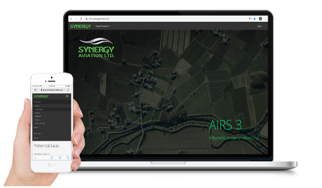
AIRS3: Keep Your Data, Reporting, and Tracking in One Place
Go beyond data collection with critical insights that create actionable results. Our team of trained pilots leverage the latest sensor technologies to ensure a comprehensive, timely, and accurate evaluation of your assets. Using our proprietary AIRS3 software, you can manage your assets from a single location. AIRS3 enables you to quickly and easily view geo-referenced anomalies such as leaks, cracks, exposed pipe, and third party activity in near real time, and be immediately notified when there is an emergency; track time and progress; and download compliant reports for regulators.
Why Drones Are Disrupting
the Oil & Gas Industry
Inspections are non-negotiable, but you don’t have to break the bank to meet regulatory requirements. Our oil & gas inspection services integrate traditional piloted aircraft with remotely piloted / autonomous aerial systems into your existing workflows to significantly reduce ongoing inspection and monitoring costs, all while improving data accuracy and optimizing safety.
Our integrated drone solutions easily navigate through complex assets and dangerous terrains, such as pipelines or offshore rigs. Capture high-resolution imagery, thermal imaging, and gas detection data from a safe distance while simultaneously providing geo-located data on the exact location and nature of potential hazards. Through drone-provided data collection, workers have instant access to the information needed to quickly and safely repair damaged assets while reducing the risk of accidents and injuries.
Reduce Scope 3 Greenhouse Gas Emissions with Green Technologies
WHAT WE DO
Boreal Methane Gas Detection
Optical Gas Detection

Corridor / Right-of-Way inspections
Lidar Mapping
