Introduction
Most aerial imaging shows what a site looks like. Lidar shows what it actually is down to the centimeter, and often beneath what a camera can even see. For infrastructure teams, geomatics professionals, and environmental planners, that’s the difference between a survey that’s close enough and one on which engineering decisions can be built. Here’s what Lidar does, why it matters, and how you can build the skills to use it yourself.
What is Lidar?
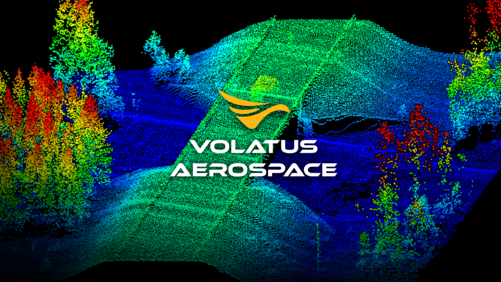
Lidar uses active laser technology to create accurate 3D point cloud data. This data includes millions of georeferenced points that can penetrate vegetation, map complex terrain and provide survey-grade accuracy for infrastructure planning, digital twins and environmental monitoring. Unlike passive imaging, Lidar uncovers hidden details: terrain beneath dense forest cover, ground-level features in difficult environments, and precise asset geometry for engineering applications.
Why Use Lidar?
1. Vegetation Penetration – Lidar lasers reach ground level beneath thick forest cover. It reveals terrain and infrastructure that traditional imaging cannot detect. It’s crucial for environmental surveys, corridor mapping, and locating buried utilities, which RGB photography alone cannot capture.
2. Survey-Grade Accuracy – Lidar provides centimeter-level precision with RTK/PPK positioning that meets engineering standards for CAD, GIS, and BIM integration. It’s reliable and can be repeated across multiple surveys, ensuring effective change detection and monitoring over time.
3. Fast & Scalable Aerial – Lidar covers large areas and challenging terrain much faster than ground surveying. They efficiently manage everything from small inspections to broader regional surveys. This reduces project timelines while maintaining precision.
What Does Lidar Enable?
Lidar powers a wide range of engineering and planning work, such as terrain models; slope analysis for grading and stormwater design; centimeter-accurate corridor mapping for transportation, utility, and pipeline networks; and canopy data for environmental and forestry assessments in areas too dense for cameras to see through.
On top of that, classified point clouds support volumetric tracking and cut/fill analysis for mining, aggregates, and construction, and repeat scans make Lidar one of the most reliable ways to monitor change over time subsidence, erosion, construction progress, and infrastructure wear catching issues early instead of after they’ve become expensive.
How Volatus Uses Lidar
Volatus runs lidar across integrated aerial, terrestrial, and mobile platforms with advanced sensors and RTK/PPK positioning, by matching the right setup for each project ranging from small, high-resolution surveys to large-scale corridor mapping. Point clouds are captured with real-time quality checks, then automatically classified into ground, vegetation, buildings, and noise, producing DTMs, DSMs, and elevation surfaces. Deliverables come in industry-standard formats ready for CAD, GIS, and BIM, backed by accuracy checks against ground control points, so every project delivers decision-ready intelligence, not just raw data.
Why Volatus
Volatus Aerospace brings Lidar expertise built on real operational experience, not just equipment. Our team has run Lidar and remote sensing projects across the energy, transportation, mining, environmental, and government sectors, working with the full range of aerial, terrestrial, and mobile platforms needed to match the right technology to each site. This operational depth is backed by senior specialists like Lee Dodson, who brings over 20 years of hands-on experience in advanced drone operations, from offshore energy and engineering to BVLOS and aerial inspections. Volatus Academy, our in-house training division, trains professionals to become certified drone pilots. Volatus Aerospace is a team that understands how the data should be used to support engineering decisions, regulatory compliance, and long-term asset management.
Next Steps
Lidar gives your team the geospatial intelligence to understand complex environments, manage assets with confidence, and plan with precision. Whether it’s infrastructure planning, environmental assessment, or ongoing monitoring, our team is ready to support your next project.
Talk to a Volatus expert about your infrastructure, environmental, or operational needs.